Location & Projects
 Building & Flat
 Back
BackProject Address
| City | Thane |
| Zone | Thane West |
| Locality | Owle Manpada Kolshet |
| Sub-Locality | Brahmand |
| Pin Code | 400607 |
| Post Office | Chitalsar Manpada |
| Police Station | NA |
Administrative Coordinates
| State/UT | Maharashtra |
| District | Thane |
| Division | Konkan |
| Taluka | Thane |
| Village | Thane (m Corp.) |
| Street | Tikuji Ni Wadi Road |
| Pin Code | 400610 |
| Locality Area | Thane, 534 |
Boundaries
| Boundaries - East Adjacent To Wing 2b At Kalpataru Hills |
Boundaries - West Gut No 59d-4-part Of Village Chitalsar Manpada |
Boundaries - North Gut No 59d-4-part Of Village Chitalsar Manpada |
Boundaries - South Gut No 59d-4-part Of Village Chitalsar Manpada |
| Survey No / CTS No / Plot Bearing No / Final Plot No. Gut No. 59d/4 - Part Of Village Chitalsar Manpada |
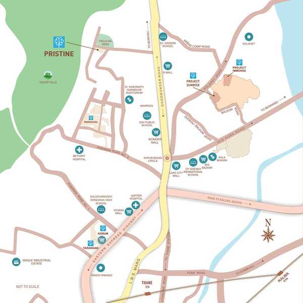
Map Address
Kalpataru Hills, Manpada, Tikuji Ni Wadi Rd, Hill Garden, Manpada, Thane West, Thane, Maharashtra 400607

Brochure Address
Kalpataru Hills, Manpada, Thane West, 400607

Municipal Corporation / Council & Ward
Thane Municipal Corporation
NA

Physical Infrastructure
Railway Station
Thane Railway Station
7.2 km
International Airport
Chhatrapati Shivaji International Airport
26.2 km
Medical Care
Bethany Hospital
3.4 km
Educational Institutes
Dav Public School
2.9 km
View More
View Less
Social Infrastructure
Malls & Entertainment
R Mall
3.2 km
Commercial Infrastructure
Business Districts
| BKC | 28.6 km |
| Nariman Point / Fort | 45.8 km |
| Andheri East | 26.1 km |
| Thane | 3.2 km |
| Lower Parel | 34.6 km |
| MIDC Chakala | 25.2 km |
 Locality & Neighbourhood
|
|
-
|
|
|
-
|
|
|
-
|
|
|
-
|
|
|
-
|
Contact Details
| Organisation Name ( Builder's Name) | NA | Organisation Type | NA |
| Website URL | NA | Office Number | NA |
| Description Of Other Type Of Organisation | NA | ||
Address Details
| Block Number | NA | Building Name | NA |
| Street Name | NA | Locality | NA |
| Landmark | NA | Division | NA |
| Pin Code | NA | Taluka | NA |
| State /UT | NA | District | NA |
| Village | NA |
| Consultant Type | As per Brochure | As per RERA |
|---|